Feature
Predicting offshore weather, one buoy at a time
Lidar buoys can make offshore development safer for wind farms and offshore installations. Alfie Shaw looks at Fugro’s weather prediction buoys.
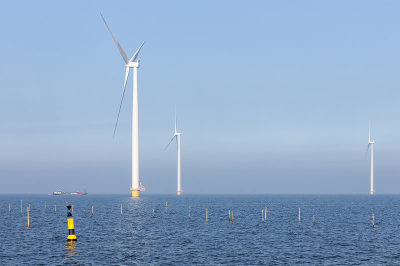
Offshore development reaches further than oil platforms. Credit: TW van Urk via Shutterstock
Life offshore can be harsh and unpredictable. Weather prediction helps eliminate some of this unpredictability, enhancing efficiency while ensuring safety. Understanding wind speeds, currents and the dynamics of waves helps design offshore structures with greater resilience, knowledge that would also become important to facilitate investment and construction in the offshore wind industry.
Private weather prediction can come from large measuring towers, but after acquiring Oceanographic Company of Norway in 2003, Dutch engineering company Fugro began making weather measurement buoys. Fugro European Metocean lead Jorn Erik Norganshol tells us that the company recently shipped its 100th buoy.
Understanding viable wind farm locations
Development of the Seawatch Lidar buoy first started in 2010 in Trondheim. This buoy records wind speeds up to 300m above the sea’s surface, along with a range of ocean weather data, or metocean geodata. This covers information such as air pressure, humidity, air and water temperature, wave height and full column current measurements.
Norganshol told Offshore Technology Focus: “The main reason for accessing the data is to understand how much wind is in a given location. When governments are auctioning out windfarm sites, they want to know how much wind there is, so they can provide information to energy companies before they bid on it. Or, private companies want an idea of how much wind there will be and therefore understand how much energy they can generate.”

The main reason for accessing the data is to understand how much wind is in a given location.
Gavin John Lockyer, CEO of Arafura Resources
Weather data can help identify the areas with sufficient wind speeds for development. The Energy Sector Management Program, a World Bank partnership that helps sustainable energy projects obtain financing, states that regions with annual average wind speeds of greater than 7 metres per second at an elevation of 100m are considered technically viable for offshore wind farms. Offshore wind data can also be gathered by offshore meteorological towers, which typically stand at around 100m high and have sensors attached to their tips. In 2019, offshore energy developer US Wind signed an agreement to install a meteorological tower at a Maryland site, enabling development of one of the country’s first offshore wind projects.
However, Norganshol highlighted the impracticality of such towers when compared to Fugro’s buoys. Towers must be built on stable parts of the seabed and cannot move once constructed. The Fugro LIDAR buoys can be placed anywhere at sea and rely on fuel cells for power, allowing them to be recharged at sea. The buoys can record wind speeds up to 300m above sea level, without needing a tip high in the sky, with the buoys themselves standing at only 7m in height, making them compact enough for road transport or air freight.
Offshore weather prediction ensures structural safety
Along with helping offshore developers locate areas of optimal wind speed, the LIDAR data can also be used to help ensure durable offshore structure design. A study by the Norwegian University of Science and Technology found that breaking waves exert high impact forces on the substructures of wind turbines. In 1989, Professor John Grue at the University of Oslo coined the term “ringing”; a type of vibration that occurs when breaking waves strike a wind turbine. The most destructive waves are those that are more than 13 metres high and have an 11 second interval between them. Grue said: “The problem is, we still don’t know exactly when the turbines may break. If we do not take ringing into consideration, offshore wind farms could lead to financial ruin.”
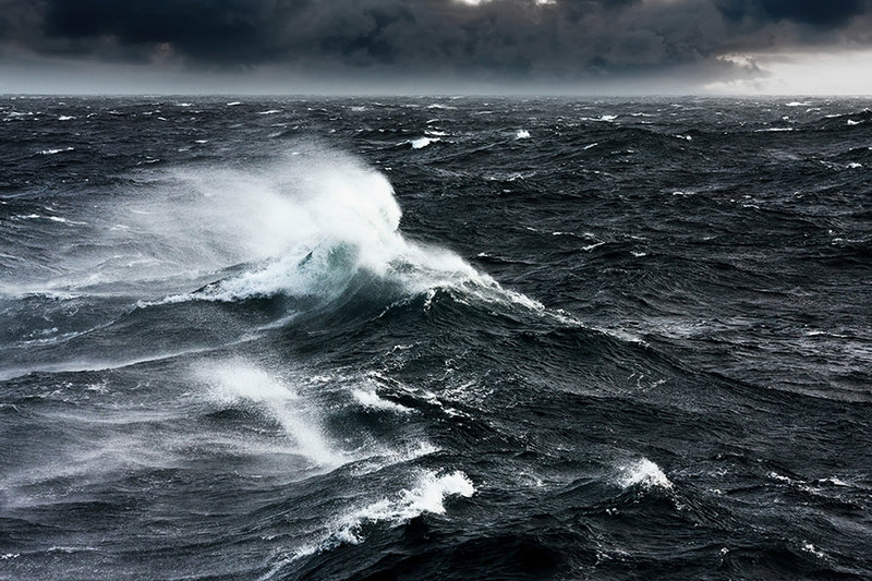
Offshore weather can damage structures. Credit: Oskari Porkka via Shutterstock
On this problem, Norganshol said: “The buoys provide data sets on currents and waves that can be used to inform offshore developers when they need to make special design considerations. In the North Sea, there can be high waves during the winter and operators need to design the wind farm to stand strong currents, fast winds and high waves.” With such data, operators can identify coastal break wave zones, where there is a high frequency of breaking waves and avoid constructing there.
Fugro offers use of the buoy as a subscription-based service, where the company deploys the buoy and the client pays for the data monthly, but Norganshol refused to be drawn on prices. Typically, a buoy will be deployed for 12 months, but some deployments have lasted two years. Norganshol noted that a period of at least 12 months is optimal, as it allows comparison of wind data between the seasons.
Renewable development buoys demand
Fugro has said that sales of the Seawatch LIDAR buoy began to spike in 2019, when governments renewed focus on offshore wind farms. In 2021 the Biden administration established a target of generating 30GW of offshore wind power by 2030. In March this year, the UK government launched the Offshore Wind Net Zero Investment Roadmap which seeks to deploy up to 50GW of offshore wind power by 2030.
In 2019, Fugro signed a Memorandum of Understanding with Underwater Survey Technology to perform wind resource assessments off the coasts of South Korea. In South Korea, regulations stipulate that geotechnical and geophysical surveys must be carried out before offshore construction begins.
In February 2022, the LIDAR buoy became the first floating lidar system in the world to reach Stage 3 of the Carbon Trust Roadmap for Commercial Acceptance of floating LIDAR technology. This is the highest commercial maturity rating, signalling the primacy of the data the buoys provide in investment decisions surrounding wind farms. As the offshore wind industry continues to grow, the need to understand wind dynamics and the movement of the seas will continue to become more important.